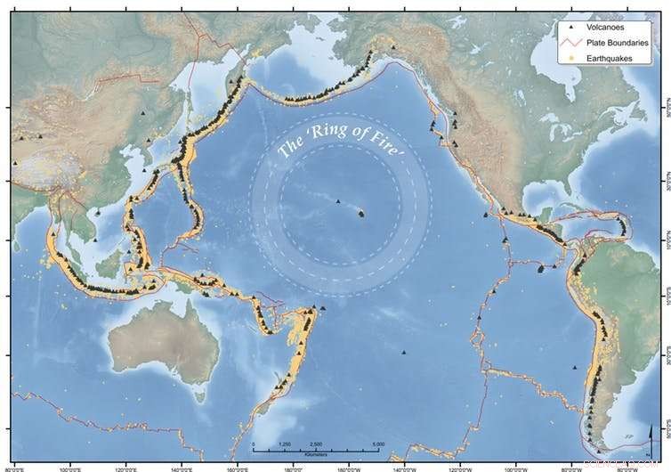
The Ring of Fire sträcker sig runt Stillahavskanten i en hästskoform. Kredit:Earth Observatory of Singapore
I Indonesien, mer än 197 miljoner människor bor inom 100 km från en vulkan, inklusive mer än 8,6 miljoner inom en radie på 10 km.
Landet har ett register över några av de mest dödliga vulkanutbrotten i historien, och just nu pågår det utbrott vid Agung, Sinabung och Dukono vulkaner. Men andra vulkaner i regionen är också aktiva, inklusive Kadovar i Papua Nya Guinea, Mayon i Filippinerna, och Kusatsu-Shiranesan i Japan.
Även om allt verkar hända på en gång, det är normalt att Asien-Stillahavsområdet har frekventa jordbävningar och vulkanisk aktivitet.
Men vi måste fortfarande hålla ett öga på saker, och lokala vulkaniska myndigheter övervakar aktiviteten för att hantera risker och evakueringar på ett adekvat sätt.
Dessa vulkaner är en del av Stilla havets "Ring of Fire", ett hästskoformat bälte av jordbävningar och vulkaner som sträcker sig över ett 40-tal, 000 km, ungefär runt Stilla havets kant. Ringen sträcker sig från Sydamerika, upp till Nordamerika och över Berings raksträcka, och ner genom Japan, Filippinerna, Papua Nya Guinea, Vanuatu och Nya Zeeland. Den genererar cirka 90 % av världens jordbävningar och innehåller 75 % av dess aktiva vulkaner.
Här är vulkanerna på min bevakningslista i Asien och Stillahavsområdet den här veckan.
Agung, Bali, Indonesien
Mount Agung på Bali har granskats mycket de senaste månaderna, till stor del på grund av Balis popularitet som turistmål.
Efter en serie vulkaniska jordbävningar (mer än 1, 000 per dag när den är som mest), utbrotten började den 21 november, 2017.
Sedan dess har vi sett frekventa explosiva utbrott som avger gas, ånga och vulkanaska som når tusentals meter över vulkanen.
Drönare som används av Indonesian Center for Volcanology and Geological Hazard Mitigation (CVGHM) visar uppskattningsvis 20 miljoner kubikmeter ny lava i kratern, fyller ungefär en tredjedel av den.
Vår drönare flög ovanför Mt Agungs krater. Lavavolymen på kraterskålen är relativt oförändrad (~20 Mm3). Magmatiska gaser som CO2 &SO2 upptäcktes fortfarande, vilket tyder på att vulkanen fortfarande kommer att få ett utbrott. Farozonen uppskattas inom en radie av 6 km från kratern. pic.twitter.com/D2GThP6fnC
— MAGMA Indonesia (@id_magma) 22 januari, 2018
På kvällen den 19 januari kastade en explosion av brand (känd som ett "stromboliskt" utbrott) ut glödande stenar upp till 1 km från kratern. Varningsnivån förblir på den högsta nivån, med en uteslutningszon på plats.
Strombolian utbrott av Mount Agung den 19 januari 2018, tiden anges i videon. Höjden på askplymens topp är cirka 2500 m över vulkanens topp. @id_magma pic.twitter.com/HeihvYzT60
— Devy Kamil Syahbana (@_elangtimur) 19 januari, 2018
Det har varit väldigt få problem för turister som besöker Bali hittills, förutom en tillfällig stängning av Denpasars flygplats i slutet av november 2017. tusentals av Agungs lokala invånare är fortfarande på flykt från sina hem, med många fortfarande stationerade på evakueringscentra. Det är fortfarande osäkert när de som bor närmast kommer att kunna återvända hem.
Många evakuerade gravida kvinnor har fött barn sedan de lämnade sina hem på platser som Bumi Sehats vårdcentral och förlossningsklinik i Ubud, som är beroende av donationer för att fortsätta fungera. Som mamma till en ettåring och en treåring, Jag kan inte föreställa mig att ha ett nyfött barn och inte vara i bekvämligheten av mitt eget hem.
Sinabung, Sumatra, Indonesien
Sinabung-vulkanen vaknade 2010 efter en 400-årig sömn, och är för närvarande en av de mest aktiva vulkanerna i Indonesien. Det har i stort sett varit i konstant utbrott sedan september 2013, och det förekommer fortfarande frekventa vulkaniska jordbävningar.
Utbrott har producerat askplymer som når så högt som 11 km upp i atmosfären, samt askfall och lavaströmmar. Det har också förekommit vulkaniska lerflöden ("lahars") och snabbrörliga, heta gasflöden, aska och stenfragment ("pyroklastiska flöden"), which have killed 25 people.
Children play outside while Mount Sinabung #volcano spews huge plumes of smoke into the skies above the Indonesian island of #Sumatra pic.twitter.com/5Cm1E44WqC
— CGTN (@CGTNOfficial) January 28, 2018
The initial activity in 2010 saw around 30, 000 people evacuated. In August last year the Indonesian National Disaster Management Authority (BNPB) reported that there were 7, 214 people displaced, and a further 2, 863 living in refugee camps. For the locals, life seemingly goes on in the midst of eruptions.
The alert level currently remains at 4 (on a scale of 1-4), with exclusion zones of 3-7km around the volcano.
Majon, Luzon, Philippines
Majon, around 330km southeast of Manila, is a picture-perfect volcano with its steep-sided conical cone, typical of stratovolcanoes. It is one of the most active volcanoes in the Philippines, with 24 confirmed eruptive periods in the past 100 years. Mayon's most violent eruption in 1814 killed more than 1, 200 people and destroyed several towns.
The recent eruption began on January 13, 2018, and is continuing, with several episodes of dramatic lava fountaining, one lasting 74 minutes.
Eruptions during January 23-29 generated 3-5km-high ash plumes and multiple pyroclastic flows, which travelled more than 5km down drainage channels. The alert is at level 4 (on a scale of 1 to 5) and an 8km danger zone is in place.
Lava flows have currently made their way up to 4.5km down river valleys from the summit crater.
The Philippine Institute of Volcanology and Seismology (PHIVOLCS) estimated on January 27 that the total volume of material deposited from ash fall and pyroclastic flows amounted to 10.5 million cubic metres. Remobilisation of this loose volcanic material by rainfall to form volcanic mudflows is a major concern.
According to news articles, more than 75, 000 people have been evacuated, along with the temporary closure of Legazpi airport around 15km away.
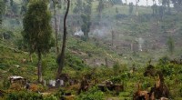
Kadovar, Papua New Guinea
Until January 2018, when it began erupting, I hadn't heard of Kadovar. It's a 2km-wide, 365m-high emergent summit of a stratovolcano off the coast of Papua New Guinea.
The volcano had no confirmed historic eruptions before 2018. However, it is possible that William Dampier, a 17th-century pirate and later maritime adventurer, witnessed an eruption at Kadovar during a voyage in search of Terra Australis .
Activity began on January 5, 2018, with rising plumes of ash and steam from the volcano. The island's inhabitants, some literally living on the crater rim, began evacuating at that time. People were initially taken by boat to neighbouring Blup Blup island but then to the mainland along with other nearby islanders, due to the close proximity of the eruption and logistics of providing people with supplies.

The top 10 countries for population within 100 km of a volcano (left) and the top ten countries (area over 31, 415 km²) for percentage of the total population (right). Credit:Sarah Brown and co-authors
The Rabaul Volcano Observatory reported that activity significantly escalated on January 12, with a large explosive eruption and volcanic rocks ejected to the south. Large amounts of sulfur dioxide have been detected since January 8, and continue to be released along with ash and steam plumes. A lava "dome" has been observed glowing at night.
The impact from the eruption is not just confined to those on Kadovar and nearby islands, with satellite imagery tracking an ash plume from Kadovar travelling over tens of kilometres.
Identified volcanic risks at Kadovar include further potential explosive activity, landslides, and resulting possible tsunamis.
Kusatsu-Shirane, Honshu Japan
On January 23, 2018, an eruption occurred at Kusatsu-Shirane volcano without any prior warning, catching Japan's Meteorological Agency and volcanic experts, not to mention the skiers on the volcano, by surprise.
Children play outside while Mount Sinabung #volcano spews huge plumes of smoke into the skies above the Indonesian island of #Sumatra pic.twitter.com/5Cm1E44WqC
— CGTN (@CGTNOfficial) January 28, 2018
According to agency's volcanology division, there had been no volcanic activity at the apparent site of the eruption (Kagamiike crater), for about 3, 000 år.
The eruption ejected a black plume of ash and larger volcanic material that damaged a gondola and the roof of a mountain lodge.
The ejected volcanic rocks, which landed up to 1km away from the vent, injured several people. A member of the Ground Self-Defence Force who was skiing in a training exercise was killed.
The Japan Meteorological Agency has since analysed the deposits of the eruption and state that there was no new magma erupted on January 23.
Japan has more than 100 active volcanoes, with many monitored 24/7 by Japan's Meteorological Agency.
Living near volcanoes
Indonesien, the Philippines and Japan have the greatest numbers of people living within 100km of their volcanoes. The populations of small volcanic island nations, such as Tonga and Samoa, almost all live within 100km.
Indonesia has the greatest total population located within 10km (more than 8.6 million), 30km (more than 68 million) and 100km (more than 179 million), and a record of some of the most deadly volcanic eruptions in history.
The eruption of Tambora in 1812-15, was the largest eruption in the last 10, 000 years and killed around 100, 000 Indonesians (due to the eruption and the ensuing famine). The infamous eruption of Krakatau (Krakatoa) killed an estimated 35, 000 personer, almost all due to volcanic-generated tsunamis. Volcanic mudflows (lahars) generated by the eruptions of 1586 and 1919 at Kelut (Kelud) in Java took the lives of 10, 000 och 5, 000 personer, respektive.
Keeping watch on the world's volcanoes is a big job for the local volcanic agencies. This is particularly true when volcanoes erupt for the first time in history (Kadovar is a good example) or there were no warning signals before eruption, as at Kusatsu-Shirane.
Denna artikel publicerades ursprungligen på The Conversation. Läs originalartikeln.