Frank Worsley, Ernest Shackletons navigatör, beräknade sin position och kartlade kurser för att rädda hela besättningen, trots iskalla, blåsiga, blöta förhållanden på små båtar som kastade i södra oceanen. Kredit:The Conversation
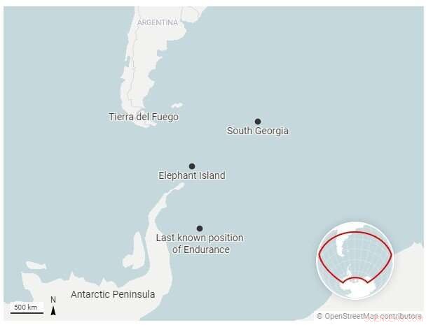
När vraket av Ernest Shackletons fartyg Endurance hittades nästan 10 000 fot under ytan av Antarktis Weddell Sea i mars 2022, var det beläget bara 4 miles från dess senast kända position, som registrerats av Endurances kapten och navigatör, Frank Worsley, i november 1915.
Det är en häpnadsväckande grad av noggrannhet för en position som bestäms med mekaniska verktyg, boklängdstabeller med referensnummer och penna och papper.
Expeditionen som letade efter fartyget hade sökt ett undervattensområde på 150 kvadratkilometer – en cirkel 14 mil tvärs över. Ingen visste hur exakt Worsleys positionsberäkning hade varit eller hur långt fartyget kunde ha färdats när det sjönk.
Men som historiker för Antarktis utforskning, blev jag inte förvånad över att ta reda på hur exakt Worsley var, och jag föreställer mig att de som letade efter vraket inte heller var det.
Navigering var nyckeln
The Endurance hade lämnat England i augusti 1914, med irländaren Shackleton i hopp om att bli den första att korsa den antarktiska kontinenten från ena sidan till den andra.
Men de landade aldrig ens på Antarktis. Fartyget fastnade i havsisen i Weddellhavet i januari 1915, vilket tvingade männen av fartyget in i tält som slogs upp på det frusna havet i närheten. Isens kraft krossade långsamt Endurancen, sänkte den 10 månader senare och startade vad som skulle bli en otrolig – och nästan otrolig – saga om överlevnad och navigering av Shackleton och hans besättning.
Shackletons eget ledarskap har blivit legendariskt, liksom hans engagemang för att se till att inte en man gick förlorad från gruppen under hans befäl – även om tre medlemmar av expeditionens 10-mannagrupp i Rosshavet omkom.
Mindre känt är vikten av navigeringsförmågan hos den 42-årige Worsley, en nyzeeländare som hade tillbringat årtionden i den brittiska handelsflottan och Royal Navy Reserve. Utan honom skulle berättelsen om Shackletons överlevnad troligen ha varit väldigt annorlunda.
Markeringstid
Navigering kräver att man bestämmer ett fartygs position i latitud och longitud. Latitud är lätt att hitta från solens vinkel ovanför horisonten vid middagstid.
Longituden krävde att jämföra den lokala middagen - det ögonblick då solen var på sin högsta punkt - med den faktiska tiden på en annan plats där longituden redan var känd. Nyckeln var att se till att tidsmätningen för den andra platsen var korrekt.
Att göra dessa astronomiska observationer och göra de resulterande beräkningarna var svårt nog på land. På havet, med få fasta landpunkter synliga, mitt i dåligt väder, var det nästan omöjligt.
Så navigeringen berodde till stor del på "död räkning". Detta var processen att beräkna ett fartygs position med hjälp av en tidigare bestämd position och inkludera uppskattningar av hur snabbt och åt vilket håll fartyget rörde sig. Worsley kallade det "sjömannens beräkning av kurser och avstånd."
Siktar mot land
When the Endurance was crushed, the crew had to get themselves to safety, or die on an ice floe adrift somewhere in the Southern Ocean. In April 1916, six months after the Endurance sank, the sea ice on which they had camped began to break up. The 28 men and their remaining gear and supplies loaded into three lifeboats—the James Caird, Dudley Docker and Stancomb Wills—each named for major donors to the expedition.
Worsley was in charge of getting them to land. As the journey began, Shackleton "saw Worsley, as navigating officer, balancing himself on the gunwale of the Dudley Docker with his arm around the mast, ready to snap the sun. He got his observation and we waited eagerly while he worked out the sight."
To do that, he compared his measurement with the time on his chronometer and written tables of calculations.
And so began one of the most remarkable rescue missions in history. In a small open lifeboat, six men sailed 800 miles across some of the roughest seas on the planet to get help. We think they navigated with these instruments, on display in #PolarWorlds pic.twitter.com/4lxgzfR1BL
— Dr. Claire Warrior (@ClaireWarrior1) March 9, 2022
A last hope of survival
Once they managed to arrive on a little rocky strip called Elephant Island, off the coast of the Antarctic Peninsula, they still faced starvation. Shackleton believed that the only hope of survival lay in fetching help from elsewhere.
Worsley was ready. Before the Endurance was crushed, he had "worked out the courses and distances from the South Orkneys to South Georgia, the Falklands and Cape Horn, respectively, and from Elephant Island to the same places," he recalled in his memoir.
The men used parts of the other lifeboats to reinforce the James Caird for a long sea journey. Every day, Worsley "watched closely for the sun or stars to appear, to correct my chronometer, on the accuracy of which our lives and the success of the journey would depend."
On April 24, 1916, Worsley got "The first sunny day with a clear enough horizon to get a sight for rating my chronometer." That same day, he, Shackleton and four other men set off under sail in the 22.5-foot James Caird, carrying Worsley's chronometer, navigational books and two sextants, used for fixing the position of the Sun and stars.
The boat journey
These men, in this tiny boat, were going from one pinpoint of rock in the Southern Ocean to another, facing high winds, massive currents and choppy waters that could push them wildly astray or even sink them. The success of this voyage depended on Worsley's absolute accuracy, based on observations and estimations he made in the worst possible environmental conditions, while sleep-deprived and frostbitten.
They spent 16 days of "supreme strife amid heaving waters," as the boat sailed through some of the most dangerous sea conditions in the world, experiencing "mountainous" swells, rain, snow, sleet and hail. During that time, Worsley was able to get just four solid fixes on the boat's position. The rest was "a merry jest of guesswork" to determine where the wind and waves had taken them, and adjusting the steering accordingly.
The stakes were enormous—if he missed South Georgia, the next land was South Africa, 3,000 miles farther across more open ocean.
As Worsley wrote later:"Navigation is an art, but words fail to give my efforts a correct name. … Once, perhaps twice, a week the sun smiled a sudden wintry flicker, through storm-torn cloud. If ready for it, and smart, I caught it. The procedure was:I peered out from our burrow—precious sextant cuddled under my chest to prevent seas from falling on it. Sir Ernest stood by under the canvas with chronometer, pencil, and book. I shouted "Stand by," and knelt on the thwart—two men holding me up on either side. I brought the sun down to where the horizon ought to be and as the boat leaped frantically upward on the crest of a wave, snapped a good guess at the altitude and yelled "Stop." Sir Ernest took the time and I worked out the result. Then the fun started! Our fingers were so cold that he had to interpret his wobbly figures—my own so illegible that I had to recognize them by feats of memory."
On May 8, they saw floating seaweed and birds, and then spotted land. But they had arrived at South Georgia amid a hurricane, and for two days had to fight being driven by wind onto an island they had spent weeks desperately trying to reach.
Finally, they came ashore. Three of the six men, including Worsley, hiked across unmapped mountains and glaciers to reach a small settlement. Worsley joined a rescue boat back to get the other three. Shackleton later arranged a ship to collect the rest of the men from Elephant Island, all of whom had survived their own unimaginable hardships.
But the key to all of it, and indeed the recent discovery of the Endurance's wreck, was how Worsley had fought desperate conditions and still repeatedly managed to figure out where they were, where they were going and how to get there.